The river starts from Binh Phuoc province, running through Tay Ninh, Binh Duong provinces and Ho Chi Minh City. The stretch in HCMC is approximately 80 kilometers long.
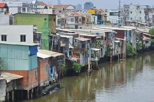
Alongside the riverbanks, lot of houses and other construction works have been built. Specifically, tens of houses are found encroach the riverbed along the riverbank from District 12 to Binh Thanh, Go Vap, Thu Duc districts and District 2. The worst transgressed area is in Thu Duc district with tens of houses and villas.
The riverbank area in Thao Dien ward, District 2 has been handed over to investors of housing and high class villas projects. They have surrounded their projects with solid fence wall in the river edge, blocking the river’s access way.
The river embankment in the right bank of the river in Districts 12, Hoc Mon and Cu Chi districts has been built for traffic also, still the route has been cut off at some spots. Specifically, a house is built right on the embankment in An Phu Dong ward, District 12. Adjacent to the house is a land plot being filled up for construction.
When the embankment project was implemented, site clearance was not completed. So many sections of the embankment now go through residents’ properties.
To tackle the river encroachment, HCMC People’s Committee has assigned the Department of Planning and Architecture to work with the Department of Tourism, the Department of Transport, HCMC Institute for Development Studies, Steering Center for Urban Flood Control Program, the management board of the urban area south of the city, nine districts and Tan Thuan Industrial Development Company to review Saigon River plan and control construction along the river.
After reviewing, they reported that the riverbank has been covered with 83 construction projects over about 454 hectares to build houses, trade and service centers and parks. Of these, 76 projects reported to affect the riverbank safety corridor as per city regulations.
Some works have been built before 2004 and some after 2004 when the city issued Decision 150 on protecting riverbank corridor.
According to the decision, rivers have a 30-50 meter wide riverbank protection corridor that is same for canals and public ponds. However many construction projects have been licensed narrowing the safety corridor to only 7.5 meters at some places.
Estimating construction situation along the Saigon River, the Department of Planning and Architecture said that projects have been approved both before and after 2004, so the riverbank corridor width has not accorded with current regulations of 30-50 meters. That has impacted riverside landscape exploitation to serve the community.
The agency proposed the city People’s Committee to estimate the status quo of riverbank encroachment, intensify inspection to handle violations, review to have overall estimation of projects and call on experts’ opinions to have plan management regulations concerning the riverside landscape.
Architecture Ngo Viet Nam Son said that the safety corridor encroachment would affect the river flow and pose a danger of landslide. To settle the issue, he said it needed to specifically consider each work and project to make clear which projects were licensed in the past and which have been licensed after the city’s issue of Decision 150 to have solutions. Those licensed after the decision issue time must be removed to return the riverbank safety corridor as per regulations.