As forecasted, the dangerous zone is expected to enter the Gulf of Tonkin today before moving in the territorial waters along provinces from Quang Ninh to Hai Phong.
Wipha is anticipated to enter Vietnam’s mainland provinces from Quang Ninh to Nam Dinh, and then it will degrade into a tropical depression and low pressure zone.
Because of the storm effect, Northern and North- Central provinces will suffer thunderstorm, cyclone, gusty wind and heavy rainfall of 100- 300 mm, even up to 400 mm in Quang Ninh and Hai Phong.
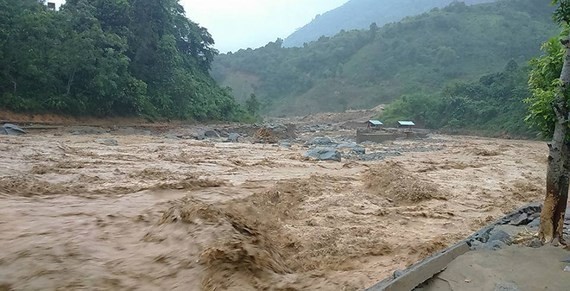
A huge flooding is able to follow the rainy and storm days in Thanh Hoa and Nghe An provinces.
The highest water levels on Thao River and the upstream of Lo and Thai Binh rivers are alerted at level 1-2.
The tropical stom is predicted to cause risks of flashflood and landslide in the Northern mountainous and low-lying areas of Lai Chau, Son La, Hoa Binh, Lao Cai, Yen Bai, Ha Giang, Tuyen Quang, Cao Bang, Lang Son, Bac Kan, Quang Ninh, Thanh Hoa and Nghe An.
Amid the current weather condition, Minister of Agriculture and Rural Development cum Head of the Central Steering Committee on Natural Disaster Prevention and Control Nguyen Xuan Cuong yesterday released a telegraph to ask the coastal provinces and cities from Quang Ninh to Da Nang to carry out necessary solutions against the typhoon.
Pursuant to the above telegraph, the local authorities need to check and monitor vehicles operating at sea, keep an eye on the bad weather condition.


