Yesterday evening, Tembin was located at around 200 kilometers eastward of the Philippines’s southern region with powerful wind gusted up to 75-90 kilometers an hour.
In next several hours, Tembin will move westward at a speed of 15 kilometers.
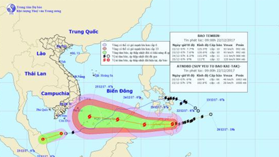
In next 24- 48 hours, Tembin is going to move the west- southwestward at a speed of 20-25 kilometers an hour, and it is expected to develop stronger.
Tomorrow, Tembin is forecast to be around 270 kilometers southward of the Philippines’s Palawan Island. The strongest wind near the center could blow at 90- 115 kilometers an hour.
Meanwhile, the northeast monsoon and storm Kai-tak caused bad weather in the East Sea, the central and southern provinces of Vietnam.
In the morning yesterday, Kai-tak was located at around 280 kilometers of the southwestward with a powerful wind of 60-75 kilometers an hour.
Within next 24 hours, it will move the west southwestward at the speed of 15 kilometers an hour.
By 4pm today, Kai-tak is expected to be at around 200 kilometers of the coastal eastern region of Malaysia with the strongest wind of 60- 75 kilometers an hour.
Because of its influence, the westward of the south- East Sea including the southwestern territorial water of the Spratly Islands will experience rainy weather, wind of level 8-11 and sea rough.
The tropical storm is predicted to continue moving the west southwestward at the speed of 15 kilometers, and enter the eastward of Malaysia and weaken into the tropical low depression and low pressure zone respectively in next 24- 48 hours.
In next several hours, Tembin will move westward at a speed of 15 kilometers.
In next 24- 48 hours, Tembin is going to move the west- southwestward at a speed of 20-25 kilometers an hour, and it is expected to develop stronger.
Tomorrow, Tembin is forecast to be around 270 kilometers southward of the Philippines’s Palawan Island. The strongest wind near the center could blow at 90- 115 kilometers an hour.
Meanwhile, the northeast monsoon and storm Kai-tak caused bad weather in the East Sea, the central and southern provinces of Vietnam.
In the morning yesterday, Kai-tak was located at around 280 kilometers of the southwestward with a powerful wind of 60-75 kilometers an hour.
Within next 24 hours, it will move the west southwestward at the speed of 15 kilometers an hour.
By 4pm today, Kai-tak is expected to be at around 200 kilometers of the coastal eastern region of Malaysia with the strongest wind of 60- 75 kilometers an hour.
Because of its influence, the westward of the south- East Sea including the southwestern territorial water of the Spratly Islands will experience rainy weather, wind of level 8-11 and sea rough.
The tropical storm is predicted to continue moving the west southwestward at the speed of 15 kilometers, and enter the eastward of Malaysia and weaken into the tropical low depression and low pressure zone respectively in next 24- 48 hours.
This early morning, a cold air mass operated strongly in the offshore central, southern region and the East Sea.
Because of the cold air influence, the offshore central, southern region and the East Sea will see the northeast monsoon of level 6-9 and big waves of 3-5 meters; the north part of the East Sea including the Paracel Islands also will experience maximum wind of level 6-9, big waves of 4-6 meters and sea rough.
Because of the cold air influence, the offshore central, southern region and the East Sea will see the northeast monsoon of level 6-9 and big waves of 3-5 meters; the north part of the East Sea including the Paracel Islands also will experience maximum wind of level 6-9, big waves of 4-6 meters and sea rough.


