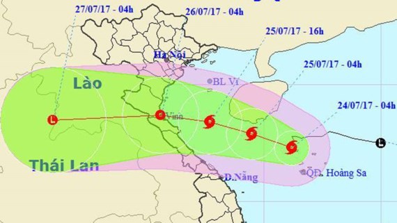
At 10 a.m. this morning, the typhoon was centered 160 kilometers southeast of Hainan Island, China. Strongest winds near the eye of the storm reached level 8 moving 60-75 kilometers an hour.
In the next 24 hours, it will move west northwest at 10-15 kilometers an hour. At 10 a.m. tomorrow, the typhoon will locate 200 kilometers east off provinces from Thanh Hoa to Quang Binh.
Being affected by the typhoon, the northern part of the East Sea has been very rough and choppy. Provinces from Thanh Hoa to Thua Thien-Hue will start seeing medium to heavy rainfall from July 25.
The Central Steering Center for Natural Disasters Prevention said that water level in the Red River, Hanoi has been surging quickly, reaching 7.54 meters on Sunday. It is forecast to reach 7.8 meters today.
The water level at Pha Lai station in the Thai Binh river will slowly increase.
Hoa Binh hydropower reservoirs opened three floodgates yesterday while Son La and Tuyen Quang reservoirs opened one floodgate to reduce flooding in the upper reaches.
The Cuu Long river the Mekong Delta has been swollen because of floodwaters from the upper reaches of the Mekong River.
It is forecast to reach the peak level of 2.8 meters at Tan Chau station in the Tien river and 2.4 meters at Chau Doc station in the Hau river on July 26.
The weather in HCMC and the southern region will be erratic from July 24-28. Temperatures will swing from 25 to 33 degrees Celsius in daytime.


