This Webgis map was built based on the web platform in order to be accessed by a laptop, a tablet, or a smart phone.
It simultaneously makes use of many map technologies from Google, Open Street, and satellites to help users look for information about one specific landslide, including length, depth, influences on the environment and residents.
Having precise data, pictures, and videos, the map is able to deliver warnings in advance and aid the propaganda about landslide effects.
After nearly 2 years launching, the Webgis map has received updated data from 13 provinces in the Mekong Delta.
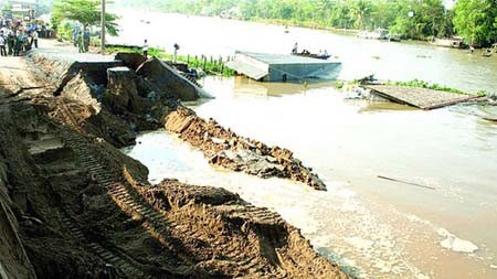
Statistics reveal that in the whole region, there are 564 hot spots of landslide along river banks and erosion of the coastline, with the total length of more than 834km. Noticeably, 104 spots with the length of 203km (accounting for 35 percent) is rated as extremely dangerous, and 121 spots (29 percent) as dangerous.
By mobilizing finance from various sources (VND11,440 billion or US$493 million), from 2011 to 2018, the local authorities of these areas were able to treat 141 hot spots of landslide and erosion.
Since 2018, the central Government, along with the aid of international organizations, has been able to gather VND7,384 billion ($318 million) to continue treating the other 102 spots of 184km along river banks and coastline.
The Vietnam Disaster Management Authority stated that the data update is still insufficient. Therefore, to complete the Webgis map as soon as possible, this organization asks that the grassroots authorities in related areas regularly check, categorize, and input updated data for the map. These pieces of information must be precise, objective, and consistent among different areas.